Consensus Planning produced a mapping application for New Mexico Land Holdings, showcasing development projects over a large area of Albuquerque’s west side. This application provides stakeholders with a comprehensive and interactive map of completed development projects, active projects, and illustrates development opportunities for investors in context with transportation and utility infrastructure. This application hosts converted CAD data of recent subdivision developments, solar facility infrastructure, and maps the boundaries of Tax Increment Development Districts (TIDD) and Public Improvement Districts (PID).
Archives: Projects
Sunland Park Zoning Map
The City of Sunland Park utilized Consensus Planning to update its GIS zoning map. City boundaries and parcel data had changed significantly since the City’s zoning map was last adopted in 2018. Consensus Planning analyzed zoning data to identify any changes between data iterations and reviewed documentation of approved zone changes make applicable updates to the data. The zoning data was then updated to correspond to current parcel data boundaries. We provided detailed documentation of where old zoning boundaries did not align with new parcel data and worked closely with City staff to identify the correct zoning. Consensus Planning uploaded the new zoning data to the City’s ArcGIS online environment, and designed, produced, and published a new web map.
City of Clovis GIS Services
Consensus Planning provides ongoing GIS services to the City of Clovis, including responding to utility, addressing, zoning, and emergency service mapping requests by all City departments; GIS support and administration; and maintenance of its GIS systems. The project started with meeting individually with City departments to strategize GIS workflows. We developed maps and mapping applications, and provided end-user training to enable departments to collect, engage with, and manage GIS data. We support City staff as they adopt and engage with GIS maps and data. Our services allowed the City of Clovis to eliminate the need to fill a full-time GIS position.
City of Raton Zoning Map
Consensus Planning created a web map application for the City of Raton’s zoning map. We acquired existing versions of the City’s zoning maps from 1987 and 2009, digitized the zoning data from the paper and PDF maps into GIS format, and analyzed the data to identify any areas of inconsistency between the versions. We provided the City with detailed maps and information regarding areas of inconsistency to allow the City to review errors and make recommendations. The new zoning map was reviewed and approved by the Raton Planning and Zoning Commission.
Rio Rancho Public Schools
Consensus Planning developed a school locator mapping application for Rio Rancho Public Schools (RRPS) that allows website users to determine their school of attendance, and view school locations and school boundary information. We also developed an internal web mapping application that hosts the school district’s GIS data, including boundaries, locations, and school-owned properties which can be securely accessed by RRPS Facilities staff.
Our services also included providing support to RRPS for redistricting purposes. By performing a geocoding analysis of the district’s student population, we were able to identify enrollment and transfer trends and provide detailed information on the number of students that would be impacted by a boundary change.
Hilton Garden Inn and Homewood Suites/Dual Brand Hotel
This new, 6-story hotel is located at the east entry to Downtown Albuquerque at Central Avenue and Broadway Boulevard along Albuquerque’s ART route and across from ABQ Innovate. The 170-room hotel is designed as a dual brand hotel, a new concept for Albuquerque that combines Hilton Garden Inn and Homewood Suites into one structure.
The first floor of the hotel includes the lobby and structured parking; the second through sixth floors include rooms and a fully-appointed outdoor deck. A 2-story parking structure is located to the west. Consensus Planning provided entitlement services, including approval through the City’s Landmark and Urban Conservation Commission and the Edo Architectural Control Committee; landscape design; and close coordination with Clark Barnes (project architect) and the City Planning Department to ensure the project’s success.
Menaul Metropolitan Redevelopment Area (MR Area) Plan
The Menaul Metropolitan Redevelopment Area (MR Area) Plan was the culmination of the third phase of the project completed on behalf of the Albuquerque City Council. The MR Area Plan identified opportunities and strategies for redevelopment activities and projects that could catalyze private investment and prevent further disinvestment in the area. It also identified public infrastructure and transportation improvements to be undertaken by the City of Albuquerque. The recommendations provided in the MR Area Plan were based on the findings of the larger Menaul Redevelopment Study, input received at three public meetings, results of a business owner survey, and individual meetings with business owners and other interested parties. The Menaul MR Area Plan was intended to initiate, direct, and facilitate positive action by the City to correct the existing blighted conditions and reverse the current trend of distress and disinvestment. The vision for the Menaul MR Area was for it to once again become a thriving business, hotel, and retail district that positively contributes to the well being of the greater community of Albuquerque.
The Menaul MR Area is located at the confluence of Interstate 40 and Interstate 25 (the Big I”) and within Albuquerque’s Mid Heights, which has historically been characterized by high levels of economic output from commercial retail and services and industrial development. The designated MR Area boundaries are Phoenix Avenue to the north, Interstate 40 to the south, North Diversion Channel to the east, and Interstate 25 to the west. The purpose of the Menaul MR Area is to facilitate this area of Albuquerque to return to being a safe and desirable destination and business hub.
PROJECT VISION:
The Menaul Metropolitan Redevelopment Area is a vibrant, walkable business district for hotel guests, workers, and residents alike. A rebirth of the area has occurred as new businesses – commercial retail and services, hospitality, and restaurants – have sprung up along the corridor and existing businesses continue to invest and take great pride in their properties. The area features a coordinated system of streets, sidewalks, multi-use trails, and transit services that provide connections to the larger Albuquerque community and encourage transit-oriented development.
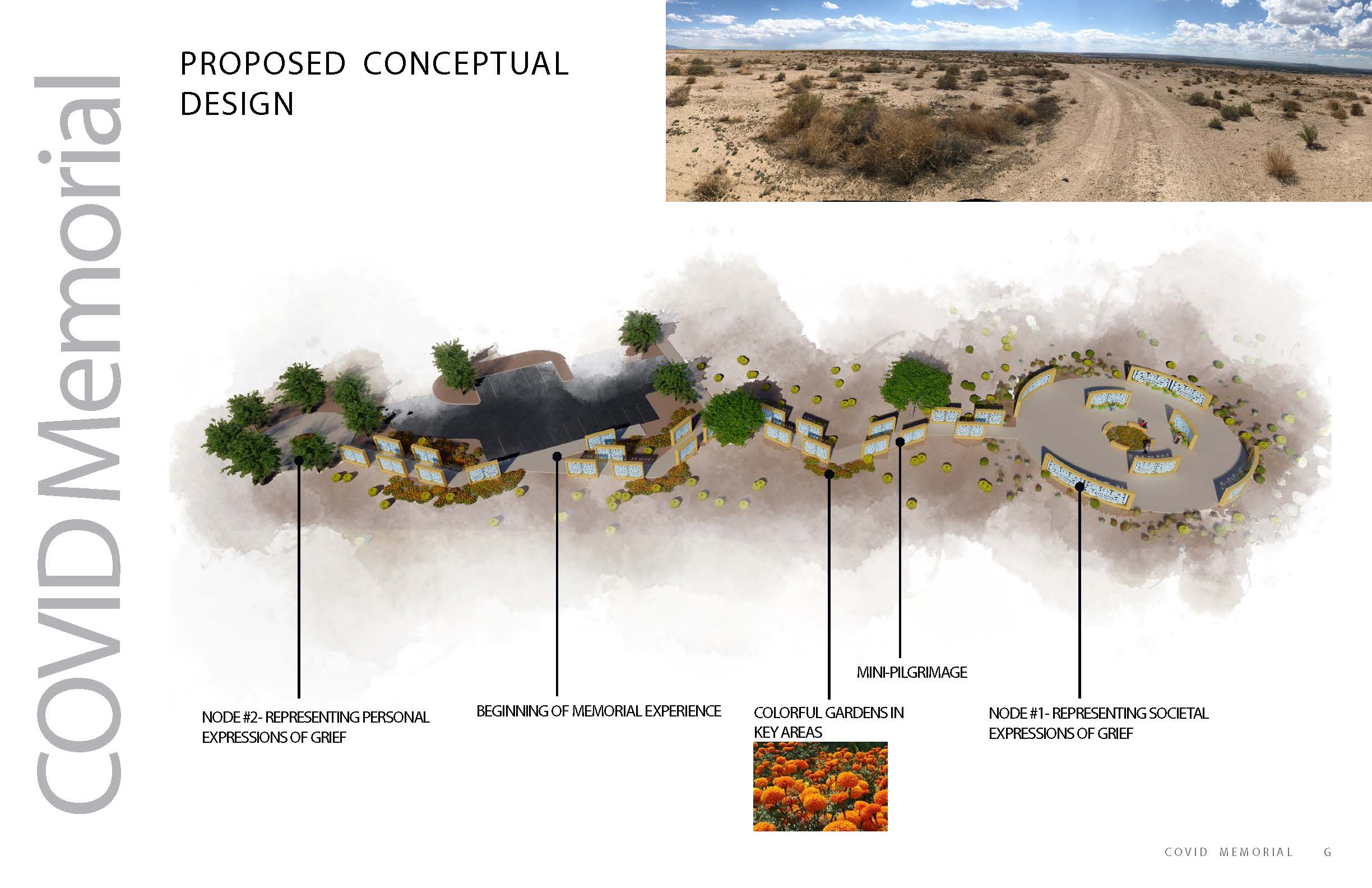
COVID Memorial
The COVID pandemic will continue to impact our work, communities, and daily lives. The lives that have been lost are palpable, still bringing pain to New Mexico families. As of October 11, 2022, 8,500 New Mexicans and more than a million Americans have died.
Many humbling questions have to be asked before one attempts to design a commemoration of those lost to COVID:
- How do New Mexicans remember?
- How do New Mexicans develop their identities?
- How do we memorialize these persons that have passed in a respectful fashion while recognizing the diversity of ways we mourn and grieve?
Fortunately, the culture of New Mexico is rich with answers to these questions.
New Mexicans have a long memory. We have tales from before the Spanish entrada that place our ancestors in the landscape and descansos and prayer sticks in the landscape that commemorate places and persons. New Mexicans identify themselves with the surrounding mountains, valleys, and sky. Bernalillo County staff and consultants found a place that represented our collective geography on the southeast mesa surrounded by our mountains, overlooking our watersheds and expressive of our identity.
The central idea of the COVID memorial is to create a small pilgrimage where one experiences places for personal and societal expressions of grief. The pilgrimage path is lit by the light filtering through picado walls creating shapes and shadows on the pavement. Many of these picado walls will have places for ofrendas, brought by people to remember persons that have suffered during COVID. The walls will be arranged to focus views mountains or the valley. Colorful plantings of marigolds are strategically planted where the trail changes direction. At the end of each path are dedicated spaces that look outward or inward for a solemn and respectful commemoration of our collective loss during COVID.
The design integrates the COVID-19 national memorial in the node dedicated to societal expressions of grief. By simply reading a QR code an array of photos will appear in a spiral pattern. Some of the photos will have stories attached to them that can be clicked on for audio files. Visitors will be able to search for a loved one who will appear in the array and will also be able to upload images of a loved one.
ABQ BioPark Zoo and Botanic Garden Entry Renovations
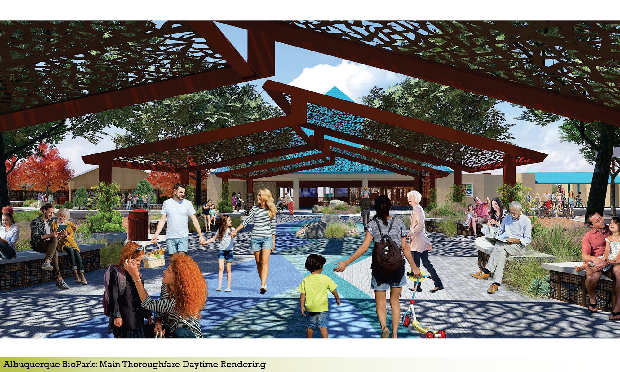
One City official described the entry into the Zoo as looking like “a border crossing”. For that reason, Consensus Planning was contracted to develop concepts for re-imagining this space to be inviting, interactive, accessible, comfortable, educational, and most importantly, memorable. The space will include improved shade and seating options; elements that are interactive and educational to keep young minds busy and engaged while waiting to enter the Zoo; improved wayfinding signage; and colorful, maintenance friendly landscaping. We developed options to bring this space to life, creating photo simulations that will assist the City in securing funding for the improvements.
Expanding on the effort at the Zoo, Consensus Planning was contracted to develop theming concepts to aid in re-branding the signage and monumentation at the Zoo and Botanic Garden-Aquarium. The existing sign at the corner of Central Avenue and New York Avenue is old and outdated, and does not present a memorable sense of arrival. The developed concepts enhance the BioPark image and create a bold, dynamic presence and photo opportunity for all users.
Tramway and Indian School Landscape Improvements
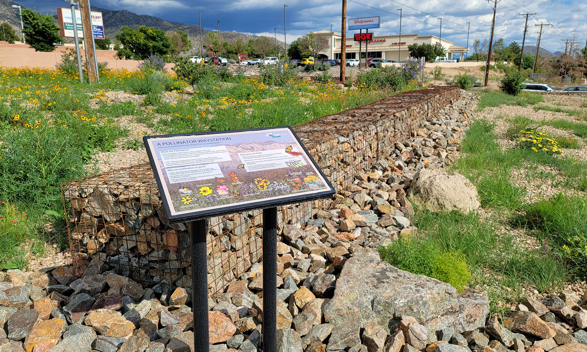
At the intersection of Tramway Boulevard and Indian School Road is a 2.2-acre landscape, which includes the Tramway Trail, an urban open space trail in the foothills of the Sandia Mountains. The site contained a prairie dog colony and was dominated by large stands of the highly invasive Ailanthus altissima (Tree of Heaven). The City of Albuquerque, along with the NMDOT, relocated the prairie dog colony to a better suited environment, addressed the Tree of Heaven infestation, and planned to re-establish the landscape at this highly visible site. The City worked with community members on a master plan to develop an attractive water-sensitive landscape at the entrance to their community that offered opportunities for running, walking, and watching the sun set; prevented the re-introduction of the prairie dogs and the Tree of Heaven; created a pollinator friendly landscape; and lastly, improved pedestrian visibility.
The design team at Consensus Planning worked collaboratively with the City, NMDOT, and Embudo Canyon Neighborhood Association at all phases of the project to ensure that all concerns and needs were being addressed. Over the various milestone meetings, national night out displays, and meet and greets, substantial input was provided by an enthusiastic community. The site is a prototype to address rehabilitating similar affected areas along the Tramway corridor.
To maintain continuity with the existing trail system and natural foothills landscape, the site was designed to blend with the existing conditions along the trail and as a native landscape corridor. Native re-vegetation seeding was applied to the site and includes a mixture of native flowers, shrubs, and grasses. The site also utilizes bioswales, rock-filled gabion baskets, and boulder retaining walls to manage erosion of the highly erosive soils and harvest the rainfall that falls on and enters the site. These natural materials echo the granite mountain foothills surrounding the site. A temporary irrigation system was installed to facilitate better germination of the seed mix and plant establishment.
The primary feature of the project is a colorful pollinator waystation at the project corner. The pollinator garden includes the installation of milkweed that attract not only monarch butterflies but native pollinators as well. A plant bloom time spreadsheet was created to ensure that a balance of nectar and pollen producing plants were available throughout the active times of the year for pollinators to have a readily available food source.
A human respite area was provided with two benches, native trees for future shade, and an expansive view looking across the valley to the West Mesa. As an educational tool, three information signs were developed to identify the invasive Tree of Heaven, promote pollinator landscapes using native and naturalized plant species; and to explain the site’s use of multiple techniques to deter prairie dog colonies from setting up home.
This project is an excellent example of how municipalities, designers, and community members can come together to collaboratively develop a project vision that ensures a projects long-term success. A well-attended ribbon-cutting ceremony was highlighted by the unveiling of a dedicatory plaque memorializing this hard work and collaboration. The project was also presented an Excellence in Sustainability award from the New Mexico Chapter of the American Society of Landscape Architects in 2021.